Two Stops on the Hill Country Bat Trail

Somewhere or other Jay heard about a bat roost near Comfort, Texas, and if that isn’t an incentive to visit that place when you’re already close by, I don’t know what is. So on the afternoon of the 14th, we went looking for it.

Comfort is a small town, pop. 2,300 or so, in Kendall County and, according to the Census Bureau, part of the San Antonio MSA. I’d put it in the Hill Country, though that’s not an official designation. Comfort’s main street (named High Street) is characterized by handsome 19th-century buildings, many made of local stone, put to 21st-century purposes, such as antique stores and restaurants that point out — or should point out — that they offer Comfort food.

To get to Comfort from San Antonio, head northwest on I-10. On Ranch to Market Road 473, a few miles east of town, you’ll find this curious structure.

Bat Roost, near Comfort, Texas
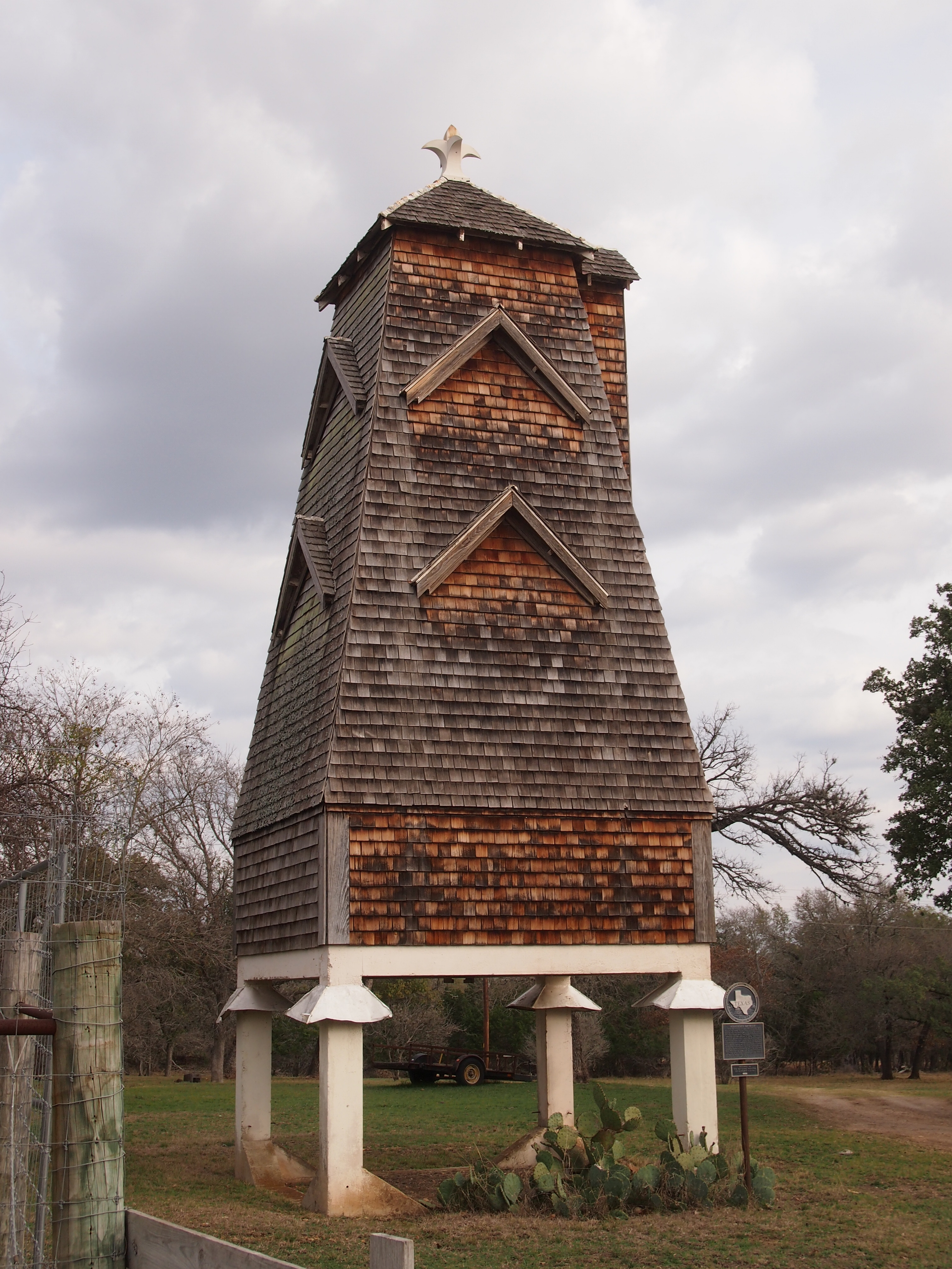
According to the Texas Historical Commission plaque at the site: “This shingle style structure was built in 1918 to attract and house bats in an effort to eradicate mosquitoes and thereby reduce the spread of malaria. It was designed for Albert Steves, Sr., a former mayor of San Antonio, by Dr. Charles A. R. Campbell, an authority on bats who had served as the health officer in the same city. Named ‘Hygeiostatic’ by Steves, the bat roost is one of 16 constructed in the United States and Italy between 1907 and 1929. Recorded Texas Historic Landmark – 1981.” It’s also on the National Register of Historic Places.

No bats were at home, it being February. I understand that they do live there in the warmer months. Different sources put the number of such towers in this country at two or three. Apparently one of the others is on Lower Sugarloaf Key in the Florida Keys.

North and east of Comfort, not far from Fredericksburg, is Old Tunnel State Park. Formerly a railroad tunnel, it’s now a home for bats. During the warm months, you can sit outside the entrance and watch bats emerge around dusk — a smaller version of the bat flight out of Carlsbad Caverns, memorable enough that I remember it after 40+ years. Again, no bats were around in February. But on hand were a couple of bat enthusiast-volunteers to tell casual visitors about the bat cave, and we talked to them a few minutes.

That’s two stops on the hypothetical Hill Country Bat Trail. Another could be the Congress Street Bridge in Austin, also known for as a bat habitat, or Bracken Cave in Comal County.

Road Eats ’14

Serendipity is your friend on the road, but you have to be open to it. After spending some time at the Wichita Public Library’s main branch in downtown Wichita on July 14, we headed west on Douglas Ave., the way we’d come into downtown. We wanted lunch, and I thought I’d seen something interesting coming in. But I couldn’t remember exactly what. Then I saw Nu Way Crumbly Burgers.

Crumbly Burgers, yumClearly my kind of place. It’s a small Wichita chain. “The Nu Way tradition began on July 4th, 1930, at the same location we still call our ‘original’ home at 1416 West Douglas,” the Crumbly web site tells us. “It all started when Tom McEvoy… moved from Iowa to Wichita and built the first Nu Way. The dedication and absolute commitment to quality Tom began can still be tasted today as we carry on his reputation.

“We still make Nu Ways with the exact same recipe using our patented cookers and we still make our world famous Root Beer daily along with our homemade Onion Rings.”

Crumbly burgers are loose-meat sandwiches and root beer is, well, root beer, and we had both (Ann’s was a float), sitting at the counter. Considering that it was mid-afternoon on a Monday, the place was busy. For good reason. Those crumbly burgers might crumble, and you have to position your wrapping to catch those loose odds of meat, but they were satisfying. The frosty chilled root beer hit the spot exactly.

Nu Way harkens back to the ’30s. In Dallas, Keller’s evokes the 1950s, I think. But not the ’50s of televised nostalgia – we saw a lot of that in the ’70s – but just an ordinary burger-and-shakes joint that’s simply never been updated. Jay calls it Jake’s, since that used to be its name, but there was some kind of family ownership split or something. We went to the one on Garland Rd., but there are a few others, including one that’s supposed to be a drive-in. Anyway, the Garland location serves tasty burgers, fries and shakes, ordered and picked up at the front counter.

Bun ‘n’ Barrel is on the Austin Highway in San Antonio. Points for actually having two apostrophes. It’s been there since I can remember (it was founded in 1950, so that makes sense). The last time I went might have been in the late ’70s. It doesn’t seem to have changed too much with time, though there’s been a few recent renovations, such as the addition of a little nostalgia-oriented decor. They’re also happy that what’s-his-name on Diners, Drive-Ins and Dives showed up to do a segment a few years ago.

Bun 'n' BarrelThere’s a barrel on the roof, but I had a hard time getting a good shot of it. Also, it was over 90 F that day, and I didn’t want to loll around outside. Instead, I snapped the painted concrete  barrel out in the back parking lot.

Bun n BarrelI got the wrong thing: a ham plate. It wasn’t bad, but it was exactly like ham I can get at a grocery store. Probably the barbecue or a burger would have been a better choice.

Threadgills in Austin isn’t a classic road-food diner or a greasy spoon, but it makes a mighty chicken fried steak. Be sure to have it with mashed potatoes and fired okra. Its nostalgia is late ’60s, early ’70s. For instance, I saw that the Jerry Garcia Fest will be at the restaurant’s beer garden this weekend. We went to the one in South Austin, one of two locations. The current restaurants are descended from a beer joint that opened as soon as Prohibition ended, with a musical heyday 40 or 50 years ago.

Finally, if you’re southbound on I-35 north of DFW and you take the very first exit after crossing into Texas, and then gas up at the gas station there, you will also see this.

Fried Pies!Among roadside eatery names, that’s high concept. Through much of southern Oklahoma, I’d seen fried pies advertised, like you can see pasties advertised in the UP. I decided it was time to investigate. It was arrayed like a doughnut shop, except replete with fried pies – bigger than the ones you buy in the grocery store, if you’re in the mood for high-calorie, barely mediocre treats. I bought a chocolate pie and a coconut one, and Ann and I split both. They were a lot better than any factory-make ones at a grocery store.

Mother Jones in Mt. Olive

Gene Autry – the singing cowboy, “Rudolph the Red-Nosed Reindeer” Gene Autry – recorded “The Death of Mother Jones” early in his career: 1931, shortly after the death of labor agitator Mother Jones (Mary Harris Jones). It’s worth a listen.

For years I’ve been seeing the sign on the Interstate advising me that Mother Jones’ memorial is off Exit 44 in Mt. Olive, Ill., not far outside greater St. Louis, but it’s been a one-of-these-days destination. The day turned out to be July 27, 2014, our last day of the trip. I’d planned to have lunch at Crown Candy Kitchen in St. Louis, and remarkably enough, I didn’t have any trouble finding that establishment. But at about 1 on that Sunday afternoon, a line was out the door. Crown Candy might be good, but not that good.

So we pressed on into Illinois. I’d stopped for lunch in Litchfield some years ago, and had a good enough memory of that, so that was the target. But then I saw the Mother Jones sign, and a billboard for a diner in Mt. Olive, pop. 2,000-plus. A winning combo. We got off at Exit 44 and followed the signs to the Union Miners Cemetery, final resting place of Mother Jones and presumably a lot of mining men. This is the view from her memorial.

Union Miners CemeteryThe view of her memorial.

Mother Jones Memorial, July 2014Why Mt. Olive? The Illinois Labor History Society tells us that Mother Jones herself made the request a few years before her death.

A Special Request to the Miners of Mt. Olive, Illinois:

When the last call comes for me to take my final rest, will the miners see that I get a resting place in the same clay that shelters the miners who gave up their lives of the hills of Virden, Illinois on the morning of October 12, 1897 [sic], for their heroic sacrifice of [sic] their fellow men. They are responsible for Illinois being the best organized labor state in America. I hope it will be my consolation when I pass away to feel I sleep under the clay with those brave boys.

— Mother Jones

Mother Jones Memorial, July 2014The monument was dedicated in 1936, and according to the society, “The cash raised for the monument was $16,393.25. All of the labor involved was donated. It stands 22 ft. high on a 20 x 18 ft. base. It is built of 80 tons of pink Minnesota granite. The name of the sculptor is lost from the record.

“The dedication was, itself, a monumental event. Five special trains and 25 Greyhound buses brought celebrants to Mt. Olive. Others came in private cars or hitch-hiked to the town. The crowd was estimated at 50,000. There were 32,000 in the line of march.”

The memorial also includes plaques to men killed in the Virden Massacre, which Jones mentioned, a gun battle in 1898 between union men and company guards over whether strikebreakers were going to detrain at a major mine in Virden. The miners prevailed, in that no one got off the train, but a number of them died. The names of the dead I saw included E.W. Smith, E. Kraemmerer and Joseph Gitterle. “General” Alexander Bradley has a plaque too, though he died in 1918.

“Who were the miners who led this fight? The best known was Alexander Bradley, a 32-year-old mule driver who worked in the Mt. Olive mines,” says Illinois Labor History… By the mid-1890s, Bradley had traveled widely throughout the Midwest, tramping with other unemployed miners to Chicago and taking part in the famous march to Washington DC of Coxey’s Army of the unemployed of 1894.

“In the course of the strike, ‘General’ Bradley, as he became known, developed a well-earned reputation as a colorful and charismatic figure. Arriving with his ‘troops’ in Collinsville, for instance, Bradley sported ‘corduroy trousers, a light blue coat, white shirt, brown straw hat, toothpick (narrow and pointed) shoes, at least three emblems of secret societies and several rings on his fingers…[as well as] a light cane or a furled umbrella.’ ”

More about Virden – “Hotter than San Juan Hill” — is here.

Tri-State Leftovers

Cool for July 2, but I know the heat will return. Such are Northern summers. Tomorrow isn’t a holiday, but it ought to be. Back to posting on Sunday.

The bridge that crosses the Mississippi from Savanna, Illinois, to Sabula, Iowa, is exactly wide enough for two vehicles, and no wider. It’s a steel truss bridge, and more than 80 years old. These facts alone make it a thrill to drive across, but a conscientious – make that sane – driver isn’t going to take in the view of the Father of Waters while crossing; he has to leave that to his passengers.

The main steel structure on the Iowa side eventually gives way to a much longer and slightly wider causeway that passes through high waters and lush green islands. At that point it’s Iowa 64, and also US 52. The last time I drove over such watery lushness was in Louisiana bayou country.

North from Sabula to Dubuque is also US 52, and a branch of the Great River Road. At this point, Illinois 84 (and a bit of US 20) is the branch of the Great River Road on the opposite bank, in Illinois. We spent a fair amount of time on both roads the weekend before last, and I can say one thing: bikers are fond of the Great River Road. We saw a lot of them on the roads and parked in various towns along the way. They weren’t usually young men, but mostly wizened fellows, probably out for the weekend.

The Great River Road is actually a chain of state and local roads passing through 10 states from Louisiana to Minnesota, or vice versa if you travel the other way. It’s a National Scenic Byway totaling over 2,000 miles, according to the Federal Highway Administration. Signs along the way look like this (and in fact we drove past this exact place).

We stopped for a moment in Bellevue, Iowa, on US 52 to take a peek at Lock & Dam No. 12. There’s a small roadside park that offers a nice vantage of the structure. Lock & Dam No 12, Mississippi River, June 2014As I got out of the car to look at the dam, I noticed a young family – husband, wife, child of three or four – also standing in the park, seemingly admiring the structure with more intensity than people usually devote to infrastructure. Odd. (My own family members were in the car.) Maybe they were a couple of young engineers. For the record, the dam creates Pool 12, with a total capacity of 92,000 acre ft. The US Army Corps of Engineers completed it in 1939 and still operates it, and the structure’s been on the National Register of Historic Places since 2004.

The campgrounds at Mississippi Palisades State Park are well-designed and expansive. They don’t cost that much, either: $10 per night for a tent site. But the wet spring and early summer, and probably the close proximity to the Mississippi and many smaller pools of water, also meant we were in close proximity to a lot of bugs. This bothered Lilly and Ann in particular – you should have heard the commotion when they discovered a spider hitchhiking a ride in the back of the car. In the vicinity of the campground itself, mosquitoes mostly weren’t the problem, or maybe our DEET kept those away. Gnats were the biggest nuisance.

By night, they’d all calmed down and the fireflies were out. Gnats = nuisance. Fireflies = joy to behold. They don’t get in your face and they put on a show.

Things You See in Mount Carroll

Somewhere or other at some time, I read that Mount Carroll, Illinois, had enough things to see to recommend a short visit (how’s that for source amnesia?). Wherever I got it, I can pass along that recommendation. It’s a small place, with only about 1,800 people, but it has a sizable concentration of historic structures. We took a look at a few of them on the afternoon of June 20.

That includes a fine courthouse, the Greek Revival part of which dates back to before the Civil War. Elsewhere on the courthouse grounds are a few monuments – but not quite as many as some courthouses I’ve seen – including a tall one dedicated to Union veterans. Turns out that Lorado Taft sculpted the cavalryman at the top of the monument, which is formally called the Carroll County Civil War Soldiers And Sailors Monument.

Mount Carroll, June 20, 2014

Writing in the short-lived blog Larado Taft: The Prairie State Sculptor, Carl Volkmann says, “Lorado Taft was a member of a team of artists who was commissioned to create the Carroll County Civil War Soldiers And Sailors Monument. George H. Mitchell designed the monument, and Josiah Schamel constructed the foundation. John C. Hall designed the annex that was added later when county officials determined that there were many names missing from the original honor roll list.

Mount Carroll, June 20, 2014“The monument consists of a fifty-foot vertical shaft with a Lorado Taft-sculpted soldier holding a flag at the top. Lewis H. Sprecher of Lanark posed for the statue and made several trips to Taft’s Chicago studio to model for it. Two additional statues are attached to the base of the monument, one an infantryman and the other a cavalryman.”

Not far from the town square is a genuine, honest-to-God Carnegie Library that is, in fact, still a library. We went in for a look around. It seemed like a nice facility for a town the size of Mount Carroll. We were the only ones in the library except the librarian – it was about 30 minutes ahead of closing time on a Friday afternoon – and I spoke briefly to her, telling her that I wanted to show my daughters what a Carnegie Library was. I also wanted to come in because they aren’t exactly common sites.

Later, I checked, and my feeling wasn’t quite right. At least according to this Wiki list, some 60-odd Carnegies are still functioning libraries in Illinois alone, out of more than 100 originally built. Seems like most of them are in small towns away from metro Chicago, so unless you frequent that kind of small town, you won’t see them much.

Just before we left town, we came across something that’s presumably not always near the courthouse in Mount Carroll: this unusual car.

Mount Carroll, June 20, 2014Unusual for American roads, that is. I don’t think I’ve ever seen a Morris Minor in this country. It’s so unusual that besides it being a Morris, I didn’t know anything else about it.

Naturally, I had to look it up. Through the marvel of Google images, I was able to pin it down to a Morris Minor 1000 Traveller. In its pages on Morris Minor history, Charles Ware’s Morris Minor Centre Ltd. in Brislington, Bristol, says “there is only one other car on British roads today which is as familiar as the Morris Minor, and that’s the Mini. That both were designed by the same man is no coincidence, and indeed Sir Alec Issigonis is one of the very few car designers whose name is recognised by the man or woman in the street and not just by enthusiasts or fellow engineers. [This might be true in the UK, but I have no way to judge that.]

“The products of Sir Alec’s genius have had a profound and highly beneficial influence on the British motor industry, so it is hardly surprising that it is his first car, the Morris Minor of 1948, which has become the subject of this proposal for a long-life car.” Morris Minor 1000 Traveller, Mount Carroll, Illinois, June 2014

More about Sir Alec here. I’m not sure I’d want to own a Morris Minor myself, but it’s a distinctive design. Good to see one loose on the roads of North America. I’m glad there are enthusiasts in this country. Any fool with money can buy a snazzy new sports car or a Lexis or the like, but it takes some imagination to invest in a Morris Minor.

The Hide Vendor of Giddings

One more item from Central Texas in late April. En route to San Antonio, Jay and I were at a stop light in Giddings, seat of Lee County, when we saw something neither of us had ever seen anywhere else.

It wasn’t the road sign marking the way to Dime Box, which I saw to the right, from the passenger’s seat. I’ve never been to Dime Box, but I remember the peculiar name — and the neighboring town Old Dime Box — from maps and because (I think) it was the capital, or at least the seat of power, in post-nuclear war Texas in the little-remembered SF novel The Texas-Israeli War: 1999.

From the driver’s seat, Jay saw something entirely more remarkable. I handed him my camera and he was able to take a shot just before the light turned green.

Texas4.25.14 067 The van at the gas station is selling Quality Hides, and you can see some hides hanging on display. But that’s not the strange thing, even though I’d never seen van-based hide selling before. This is central Texas, after all. Lots of cattle around. A hide-seller’s no big deal.

Look a little closer, between the Texas flag and the Quality Hides banner.

We Take BitcoinBITCOIN Accepted Here.

Oh, really? What’s the story here? A dealer in hides so libertarian in his sympathies — so anarchist maybe — that he takes, or wants to take, the famed cryptocurrency? What are the odds that someone driving along in Giddings, Texas, on a fine spring day will be in the market for a hide and just happen to have a Bitcoin or two burning a hole in his virtual pocket?

Or is this just the vendor’s idea of a joke? Guess I’ll never know for sure.

Independence Hall & the Brazos

The main attraction at Washington-on-the-Brazos State Historic Site, as far as I’m concerned, is Independence Hall. Texas Independence Hall, that is, a much more modest and lesser-known structure than the one in Pennsylvania.

Independence Hall, Texas 2014Actually, it’s the second replica of the original building, dating from the 1950s, which replaced a 1910s replica put on the site. There’s something to be said for replicas or even hasty copies. After all, much of what survived the golden age of Greek civilization was through Roman copies.

The display inside is refreshingly informal. Go in through the open door and there you are. There are no roped off areas, probably because everything inside’s a recent copy. Not that there’s much inside. Just a few long wooden tables, some straight-back wooden chairs, and a couple of jugs, maybe to represent the hard cider on hand to steady the delegates’ nerves. The small obelisk just outside the door says On This Spot Was Made the Declaration of Texas Independence – March 2, 1836.

There isn’t much else, at least in the way of structures, near Independence Hall. Various paths lead off from it through the rest of the historic site, including one to the Brazos River. The scenery along the way looks like this, at least in late April in a non-drought year.

Texas4.25.14 064Before long you arrive at the banks of the Brazos. It seems like an under-appreciated river. For a moment I thought I’d never been to its banks before, but of course I have – and not that long ago, when I walked along the Brazos in Waco in 2009, and even crossed it on a footbridge. But it hardly seems like the same river, even though maps tell me that it is.

Texas4.25.14 065Something I didn’t know about the Brazos before today: it’s the 11th longest (source-to-mouth) river in the United States, according to the U.S. Geological Survey, and for that matter the longest within Texas. It used to be navigable as far north as Washington-on-the-Brazos, but its career as a river of commerce didn’t really take off. Finally, no less an authority than Hank Hill says that Alamo Beer is “from the lukewarm headwaters of the mighty Brazos River.”

Washington-on-the-Brazos State Historic Site

Not far south of College Station and Bryan is Washington, Texas, an unincorporated place with a small population. In some alternate universe, it’s a major city sprawling along the Brazos River in Washington County – and it’s the capital of Texas (the state, or an independent nation; maybe that’s two different alternatives), best known for a large public university, its tech industry, and a thriving music scene. Popularly called Brazos, to distinguish it from that other Washington on the Potomac, the city also has a countercultural streak: Keep Brazos Weird, the bumper stickers say.

For a while, little Washington on the Brazos River was the capital of the Republic of Texas – 1842 to the end of independence in 1845, but then a town further west permanently won the prize of state capital, where it remains. Along the way, the back-and-forth of the Texas capital location led to the odd incident known as the Archive War, which wasn’t really a war, and which I don’t remember being discussed in 7th grade Texas History class.

These days, Washington, Texas, is best known as the site Texas declared independence from Mexico in 1836, a fact that was taught in Texas History class. That event is memorialized at the 293-acre Washington-on-the-Brazos State Historic Site, owned and operated by the Texas Parks and Wildlife Department. More about it here.

Jay and I took a look at the site on the way from College Station to San Antonio on April 25. I’d never visited before. The site has three major components: Independence Hall, the Star of the Republic Museum, and the Barrington Living History Farm. We saw the first two, along with the visitors center, where we each bought a small Come and Take It flag in the gift shop because how many places can you do that? (Amazon doesn’t count.)

Near the visitors center is a bronze of this fellow: George Campbell Childress (1804-1841).

Childress, April 2014Another of the long line of Tennesseans who came to Texas early, and a brother-in-law of James K. Polk, Childress was honored with this bronze because he’s acknowledged to be author of the Texas Declaration of Independence. Note the quill and scroll. He was head of the committee tasked on March 1 to write a declaration, and it was ready the next day, so it seems likely that he’d already prepared the thing. The document clearly owes a rhetorical debt to Jefferson. The first paragraph says:

When a government has ceased to protect the lives, liberty and property of the people, from whom its legitimate powers are derived, and for the advancement of whose happiness it was instituted, and so far from being a guarantee for the enjoyment of those inestimable and inalienable rights, becomes an instrument in the hands of evil rulers for their oppression.

Even so, the list of grievances is specific to the time and place, such as abrogation of the 1824 Constitution of Mexico and the annoying union of Texas with the state of Coahulia, but mainly boiling down to the assertion that no dictator in Mexico City’s going to tell us what to do.

Texas4.25.14 052The deco-like statue itself dates from 1936 – the centennial of Texas independence – and was done by Raoul Josset, a French sculptor who immigrated to the United States in the early 1930s, and left behind a number of works, including Childress but also “The Spirit of the Centennial,” now in Fair Park in Dallas, and the Fannin Monument in Goliad, Texas. More about Josset here.

Atlanta ’10

About three years ago on the way to Springfield, we stopped in Atlanta, Illinois, which isn’t far from I-55 but which used to be right on U.S. 66. These days that means there’s enough nostalgia traffic – and probably local regulars – to support the revived Palms Grill Café. We ate there three years ago, only a short time after it re-opened. Some years before that an artist named Steve Estes painted a mural dedicated to the original joint across the street.

A helpful sign under the mural says: “In its early days, weekly dances and bingo nights accompanied the blue-plate specials served at the Palms Grill Café. The “Grill” was also Atlanta’s Greyhound bus-stop. You just turned the light on above the door if you wanted the bus to pick you up. Located directly across Rt. 66 from this mural, the Palms Grill Café served Atlanta’s citizens, as well as a steady stream of Rt. 66 travelers, from 1936 until the late 1960s.

In his design of the “Palms Grill Café” mural, Steve Estes of Possum Trot, Kentucky, captured the intent of the “Grill’s” first owner, Robert Adams, an Atlanta native, who named it after a restaurant he frequented during trips to California. The mural was completed in June 2003 during the “LetterRip on Rt. 66” gathering of approximately 100 Letterheads in Atlanta.

The Letterheads are a group of generous and free-spirited sign painters from across the United States and Canada who are interested in preserving the art of painting outdoor signs and murals.

Just down the street from the mural is a small park with a handful of memorials. This stone caught my eye.

The modern sign says:

Knights of Pythias “Memorial Tree” Stone

This stone was dedicated by the Atlanta, Illinois Knights of Pythias organization as a memorial to veterans of World War I. The stone was placed under a Memorial Tree on November 11, 1921. At some unknown date, the stone was removed from its original location. It then rested behind the Atlanta Library for many years. Research continues to identify the exact location of the memorial tree. Atlanta’s Acme Lodge #332 of the Knights of Pythias was organized in 1892. No longer active in Atlanta, the Knights of Pythias, is an international fraternity founded in 1864, whose motto is Friendship, Charity and Benevolence.

Can’t remember which tree was planted by the Knights of Pythias, eh? Just goes to show you that no matter how fervently one generation wants later ones to remember something, they probably won’t. Or if they do, it’s a matter of chance as much as anything else. Then again, you can also make a reasonable argument along the lines of, Who cares which tree a long-gone fraternal order planted in an obscure town in the heart of North America in the early 20th century? Really important things will be remembered. (Except that they usually aren’t. Except by historically minded eccentrics.)

The Atlanta Library is an octagon dating from 1908. That’s a fine shape for a building. There need to be more of them. The exact reasons for choosing that shape for this library are probably lost, but I’d think it made for better lighting in an era when electric lighting, though available, wouldn’t have been as bright as later.

According to the library web site: “Near the turn of the 20th century, the Atlanta Women’s Club established a committee with the purpose of erecting a Library building. Land located next to the tracks of the Chicago and Mississippi railroad, was donated to the City of Atlanta by Seward Fields, a descendant of William Leonard. Leonard was one of the contractors responsible for helping build the Chicago and Mississippi railroad… A beautiful bookcase dedicated to Seward Fields is still in use at the Library.

Mrs. Martha Harness Tuttle… helped fund the erection of the Atlanta Library building.  In 1908, she donated $4,000 – over half the funds needed for the new structure. The Library Board adopted plans for erecting an octagonal-shaped structure as prepared by architect Paul Moratz, of Bloomington, Illinois… The new building was dedicated on Saturday, March 28, 1908.

The Opera House and the Box It Came In

I’ve said it before, and I’ll say it again: acknowledge the famous, or at least the noteworthy, but don’t ignore the obscure. Never know what you’ll find in obscurity. Besides, odds are you yourself are obscure. It’s the human condition, or rather the condition of most humans.

That’s an over-long intro for the Sandwich Opera House, which we chanced on after seeing the Farnsworth. Sandwich, Illinois, is a town on U.S. 34 in southeastern DeKalb County. The Opera House dates from the golden age of opera house construction in small-town America, the late 19th century. It’s apparently also the City Hall. It was closed, but you could admire it from across the street.

It’s still in use for entertainment. For a little contrast, I took a picture of this brutalist box of a building across the street.

Maybe it isn’t beyond saving. What it needs is a lick of paint – some DayGlo green, say. It could be the Green Cube of Sandwich.